Welcome to the Official Website of the Ministry of Fisheries and Blue Economy

Joint Management Area (JMA) of the Extended Continental Shelf

Extended Continental Shelf of the Mascarene Plateau

The Joint Management Area (JMA) is an Extended Continental Shelf (ECS) area of about 396 000 km², of which Seychelles and Mauritius share joint jurisdiction.

In 2007, considering the overlap in the extended Continental Shelves of Seychelles and Mauritius in the Mascarene Plateau Region, the two Governments resolved to make a joint submission to the UN Commission on the Limits of the Continental Shelf (CLCS). Dedicated teams from the two countries worked arduously, with the support of the Commonwealth Secretariat throughout 2007 and 2008, and on 1st December 2008 lodged the Joint Submission. Technical teams worked together to defend the Joint Submission, and in March 2011, the CLCS made recommendations, confirming the joint jurisdiction of Mauritius and Seychelles over 396,000 km2 of seabed and subsoil of the extended continental shelf beyond their respective EEZ.

Following the recommendations, two treaties were signed by Seychelles and Mauritius in March 2012 concerning the joint jurisdiction of the JMA of the Mascarene Plateau region and concerning the joint management of the ECS of the Mascarene Plateau region.

Under the first Treaty, the two states established the outer limits of the extended continental shelf in order to provide for its recognition under the respective national laws and for the purposes of international law. They also agreed to exercise sovereign rights jointly for the purpose of exploring the continental shelf and exploiting its natural resources. This is reflected in the relevant provisions of the 1982 United Nations Convention on the Law of the Sea (UNCLOS, which provides that a coastal State has exclusive sovereign rights over areas of continental shelf extending beyond the limits of the Exclusive Economic Zone, but in respect only of the exploration and exploitation of the mineral and other non-living resources of the seabed and subsoil (such as oil, gas and other hydrocarbons), together with sedentary marine living organisms.

The second Treaty, which has a lifespan of 30 years established the Joint Management Area (JMA) and provided an institutional and regulatory framework for its management, including the conservation, development and exploitation of its natural resources. The treaty is unique and is the first of its kind as it makes provisions for the joint management of the largest area of maritime space in the world that is subject to joint management.

Both the Governments of Mauritius and Seychelles have fully subscribed to the 2030 Agenda for Sustainable Development and the Paris Agreement on climate change therefore there is a strong focus on the Sustainable Development Goal (SDG) 14 which concerns “life under water”, and comprises of setting up a framework to sustainably manage and protect the marine ecosystems from adverse anthropogenic sources.

Both countries therefore reaffirmed the importance of jointly managing the natural resources of the Joint Management Area in such a manner that is sustainable and consistent with the precautionary principle and the protection of the marine environment and biological diversity of the area.

Management Framework

The JMA is managed using a three-tiered administrative structure.
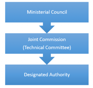
  • Ministerial Council is established as a body composed of an equal number of Ministers appointed by Seychelles and Mauritius, will consider any matter that relates to the operation of the Treaty that is referred to it by either Contracting Party or at the request of the Commission.
  • Joint Commission is responsible for establishing policies and regulations concerning activities in the JMA and overseeing the work of the Designated Authority composed of Commissioners appointed by each of the Contracting Parties. Its powers and functions are specified in an Annex to the Joint Management Treaty, and, during the first three years following the entry into force of the Joint Management Treaty, will have responsibility for designating the Designated Authority.
  • Designated Authority is established by the Joint Commission and will have juridical personality, is the body with day-to-day responsibility for regulation and management of activities in the JMA. Some of its powers and functions (specified in Annex 4 to the Joint Management Treaty) include the following:
    • managing and regulating the day-to-day natural resource activities in the JMA;
    • applying regulations and giving directions on all matters relating to the supervision and control of natural resource activities; and
    • acting as a repository of all data and information pertaining to the JMA

However, for now, a Designated Authority has not been established. Therefore the focal person for Seychelles is Mr. Chrissant Barbe, the Principal Policy Analyst of the Department of Blue Economy. Whereas for Mauritius, the focal person is Dr. Rezah Badal, Director General, Department of Continental Shelf and Maritime Zones Administration and Exploration, Ministry of Defence and Rodrigues.

As part of the management, framework three major legal instruments have been agreed upon by the two countries for proper and effective management of the jointly managed area:

  1. Marine Scientific Research Code
  2. Joint Fiscal and Taxation Code
  3. Environmental Code of Practice

These legal instruments need to be domesticated in both country’s legislations.

Strategic Plan for the Development of the JMA

There was a three-year Strategic Plan for the Development of the Joint Management Area from 2018-2020 that focussed on the sustainable management of the resources on the seabed and subsoil of that area. Being the first strategic plan for the management of the area, its aim was to set the scene for the proper, effective and efficient development of the Joint Management Area (JMA) and the establishment of the necessary structures for the sustainable management of the resources in its seabed and subsoil.

Since that Strategic Plan was only for 3 years, a new Strategic Plan is being developed which will cover the next 5 years.

UNDP Standalone JMA Demonstration Project

Background

In September 2007, UNDP began the implementation of the GEF-funded Agulhas and Somali Current Large Marine Ecosystems Project (ASCLME) with the objective of undertaking an environmental baseline assessment of the Agulhas and Somali Current Large Marine Ecosystems under one initial assessment process, wanting to fill information gaps needed to improve management decision-making, and to ascertain the role of external forcing functions such as the Mascarene Plateau and the Southern Equatorial Current

The final delivery was a Transboundary Diagnostic Analysis (TDA) leading to a Strategic Action Programme (SAP) for the regional LME management approach as per the objectives, which was endorsed by all participating countries

This SAP implementation project was formally approved by GEF in November 2013 as the Strategic Action Programme Policy Harmonisation and Institutional Reforms’ (SAPPHIRE) project and was developed to take the TDA-SAP development process to the next stage of implementation. Five components were identified with component four being the “demonstrating innovative management mechanisms for dealing with high seas areas and, specifically, extended continental shelves”.

The treaty between Mauritius and Seychelles and the JMA was seen as the ideal space and opportunity to demonstrate such innovative management mechanisms and could provide valuable lessons and best practices for replication throughout the western Indian Ocean LMEs as well as the Global LME community at large.

After consultations with both countries, it was agreed that, although the project should remain within the framework of the GEF SAPPHIRE project, the JMA part will be implemented as a separate standalone UNDP initiative, remaining closely linked to the overall SAP implementation process with close coordination within the SAPPHIRE project, and hence begin the implementation of the Standalone Demonstration Project for the JMA.

The JMA represents the first ‘transboundary’ management agreement for an ECS scenario and in 2017 GEF approved the funding of the Demonstrating Innovative Ocean Governance Mechanisms and Delivering Best Practices and Lessons for Extended Continental Shelf Management within the Western Indian Ocean Large Marine Ecosystem Project or the UNDP-JMA Standalone Demonstration Project for the sum of USD 2.2M. The project originally had a lifespan of four years and the UNDP is the responsible body with the mandate to implement it from 2018-2021. The project management unit is based in Mauritius and the project manager is a Seychellois. The project is currently being explored further so as to extend its lifespan to the year 2023.

The Project

The UNDP-JMA Standalone Demonstration Project will identify and demonstrate new management approaches and techniques concerning database management for the Mascarene Plateau.

It will assist both Seychelles and Mauritius in the development and demonstration of new management approaches bridging the gap between science and policy in the ECS. This can provide lessons and management techniques that can be replicated both within the Western Indian Ocean as well as in other similar maritime zones globally.

The UNDP-JMA Standalone Demonstration Project would also attempt to identify the data gap in terms of the underlying living and non-living resources in the joint zone. It aims at achieving its objectives through the delivery of four components as follows:

  1. Building technical and management capacity in support of an MSP framework and effective management of the Joint Management Area.
  2. Development of a data and information system along with a program of data capture and gap filling as a foundation for an adaptive management strategy.
  3. Adoption and implementation of an MSP approach with the objective of improving and implementing effective decision-making for activities within the Joint Management Area.
  4. Monitoring, Evaluation, Adaptive Feedback and Sustainability, using UNDP and GEF tracking tool for both annual progress and terminal evaluation.

Marine Spatial Planning for the JMA

Component 3 of the UNDP-JMA Standalone Demonstration Project the MSP for the JMA aims to develop a marine spatial planning (MSP) process that can form the basis for an agreed management strategy, with adopted decision-making and adaptive management mechanisms. This will be supported by efforts to: (a) build technical and management capacity that can undertake and maintain a marine spatial planning process; and (b) provide support and assistance in developing a centralised data and information system for the management of the JMA. A key feature of any MSP initiative is that it must address and resolve areas of incompatibility and conflict. MSP is based in social, institutional, legal and political threads and can therefore be a complicated process through which to achieve consensus. In addition, MSP takes into account spatial and temporal conditions, which require this tool to be relatively flexible in its application.

Applying MSP in an ECS context is even more complex due to the limitations placed on the coastal State to regulate the full range of activities and interests that operate in and around the waters adjacent to the specific area of continental shelf. In order to find the optimum way forward to manage the JMA, Mauritius and Seychelles need to explore the full range of measures available to them, and the consequences of applying those measures, even if, in some cases, those measures are as yet untested. In this way, Mauritius and Seychelles can test different management strategies to determine which may be the most appropriate and effective for the specific circumstances of the JMA. The key output from PHASE 1 of the MSP process for the JMA is a comprehensive “MSP Roadmap” that will guide the project’s MSP implementation, which will be in PHASE 2 of the project.

The Unique Situation of the MSP in the JMA

The JMA MSP is very unique being the first marine spatial plan over an extended continental shelf ECS area and is being managed using a joint management framework by two small island neighbouring states. This places the JMA and both Seychelles and Mauritius in a cutting-edge position to take the lead in piloting new mechanisms and strategies for such joint ECS management in Areas Beyond National Jurisdiction and in the High Seas, to showcase and be the advocates for collaboration and cooperation to the African region and to the world.

Monitoring, Control and Surveillance securing the JMA

Monitoring, control and surveillance (MCS) is one of the key components within Maritime Spatial Planning (MSP), necessary for assuring safety of Joint Management Area (JMA) resources and efficient control of all activities in the area in the future. JMA is, however, very spacious (covering over 400,000 square kilometers in the South West Indian Ocean (SWIO)) and in a remote location – from both Mauritius and the Seychelles (ca. 1000 km from each capital to central Saya de Malha bank area) and patrolling the area is a logistical and financial challenge. The JMA Demonstration project aims to develop a marine spatial planning (MSP) process that can form the basis for an agreed management strategy, with adopted decision-making and adaptive management mechanisms. One of the management mechanisms within MSP is Monitoring, Control and Surveillance (MCS).

MCS mechanism has been firstly developed within the fisheries sector, and although it is still most used for the monitoring activities, regulation and enforcement of those regulations within fisheries sector, nowadays its’ use covers more than fisheries. With spread of tools available, modern MCS use is broadened to monitoring, control and surveillance of all activities happening in the areas of marine jurisdiction and beyond – such as, fisheries, as an aid in search and rescue operations, as an aid in fight against criminal activities on the seas (illegal, unreported and unregulated fishing (IUU)), human trafficking, protected species trafficking and hunting, smuggling of goods, intentional or unintentional oil spills and pollution, and etc.), weather monitoring (e.g. cyclone activity and direction) or climate change adaptation activities, and etc.

The JMA, essentially is the high seas area, has very limited data sources which would help to map all possible activities in the area. A number of international (global and regional) bodies and treaties manage ocean resources and human activity in the areas beyond national jurisdiction (ABNJ). However, these governance bodies vary greatly in terms of their mandate, geographic scope, their objectives, the legally binding nature of decisions they adopt, and whether they regulate one or several activities. Their jurisdictions often overlap, but virtually no mechanisms exist to coordinate across geographic areas and sectors. Most high seas governance organizations operate under mandates that consider only one sector, such as fisheries, shipping, or mining (PEW, 2017).

Some of the activities in the JMA have been identified with great certainty (e.g., fisheries and maritime transport) while others (e.g., certain illegal activities) are suspected from available literature, Internet sources (e.g., marine traffic monitoring).  Number of new activities is foreseen for the near (5 years) to medium distant (10 years) or far more distant future. Effect of those activities is yet to be fully understood.

JMA-MCS System

Basically, there are two basic ways to proceed with building of MCS system for the JMA:

a)      Stand-alone JMA-MCS system

The stand-alone MCS system, would be a self-sufficient system that has all elements of MCS independent from existing national structures. all remote surveillance data, e.g., VMS, AIS, satellite imagery, etc., would be self-obtained and processed for further use. It also requires other two components of MCS – monitoring and control, to be to higher or lesser degree independent from existing bodies. the sole advantage of such system would be independent data control and processing, while disadvantages are numerous.

b)      Regional Network Supported JMA-MCS System

Unlike the stand-alone independent MCS system, regional network supported system is semi-independent system that can take all possible advantages of existing national and regional MCS structures.  

Both countries have existing national MCS systems that are more-less adequate for the existing coastal and EEZ waters. However, JMA is far and vast area of ocean that makes surveillance extremely challenging with assets presently available in both of countries, although not impossible.

The primary benefit of a regional network supported system would be access to regional remote sensing data sets (VMS, AIS, SAR, VIIRS, satellite video and imagery, etc.) and intelligence. Physical surveillance (air and sea) would mostly lie upon Seychelles and Mauritius, since regional structures (meaning, other member states of various regional MCS affiliated organisations) would not have high interests to increase frequency, above usual, of physical presence in the JMA – in other words, members (countries) of regional structures would have no reason to agree with special status of JMA as they would have their own interests and have no special interest in the JMA. Still, even some of physical surveillance could be occasionally covered by the regional organisation(s).

Suggestions have been made to develop JMA-MCS through two phases:

PHASE 1: JMA-MCS shall start operations through existing national structures by extending monitoring, control and surveillance procedures to cover JMA.

PHASE 2: Development of semi-independent Regional Network Supported JMA-MCS System